Refuge des Oulettes de Gaube from Pont d'Espagne
Walk 6045
Country - France
Region - Haute Pyrenees (65)
Author - Lou Johnson
Length - 14.0 km / 8.8 miles
Ascent - 715 metres / 2360 feet
Descent - 715 metres / 2360 feet
Grade - moderate
Click image to visit gallery of 12 images.
This valley walk explores a section of the French Pyrenees to the south of Cauterets. The latter town was once famed for its hot springs that made it a fashionable destination during the roaring twenties. Toady the accent is very much on the outdoors, with summer and winter mountain-based activities the source of much of its tourism income.
To reach the start of this walk, follow the D920 south through la Raillère to the large car park at the end of the road for public access just short of Pont d'Espagne. After parking, walk along the road (ignoring the temptation of using the Télécabine du Pountas) to reach the historic Pont d'Espagne. This is decision time. You can turn left here and follow the path uphill to Lac de Gaube or alternatively continue a few hundred metres further up the Marcadau valley and take the télésiège de Gaube and gain some metres at the loss of some Euros. Assuming you take the easier option, leave the top station and take the signed path to Lac de Gaube. The scenery is immediately grand and dramatic.
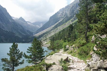
The path descends gently for a short section before levelling off and soon reaching the lake side. You can bear left to the hôtellerie if you need refreshment otherwise go right and follow the path along the west side of the lake. The path narrows considerably but offers some good views across the lake and south along the Vallée de Gaube with an impressive array of mountains, including Vignemale (3298m). This is the highest summit in the French Pyrenees and also includes a number of lesser summits.
Continuing up the valley the path is never in doubt as altitude is gradually gained. The path, initially on the west bank of the stream, crosses and re-crosses what is a very picturesque watercourse with many torrents and waterfalls. As you near the Refuge des Outlettes de Gaube the north face of Vignemale becomes more dominant. Offering many serious routes this face adds drama to the head of the valley. Hidden from view is the largest glacier in the Pyrenees and it this that offers the "voie normale" or standard route to the summit. The refuge offers a wide range of mountain food in season together with the usual dormitory accommodation.
The return route follows the outward route as far as the northern shore of Lac de Gaube. Here you can make the short diversion to the right and visit the hôtellerie or bear half right and follow the river downstream to Pont d'Espagne. Here you bear right back to the start. The other option from this end of the lake is to return by the cableway. However this involves a short section of uphill walking!
Suggested Maps
 - IGN Carte de Randonnée - Vignemalle - Ossau, Arrens, Cauterets - 1:25000 Sheet 1647OT
Stay Safe
Do enjoy yourself when out walking and choose a route that is within your capabilities especially with regard to navigation.
Do turn back if the weather deteriorates especially in winter or when visibility is poor.
Do wear the right clothing for the anticipated weather conditions. If the weather is likely to change for the worse make sure you have enough extra clothing in your pack.
Do tell someone where you are planning to walk especially in areas that see few other walkers.
Do take maps and other navigational aids. Do not rely on mobile devices in areas where reception is poor. Take spare batteries especially in cold weather.
Do check the weather forecast before leaving. The Met Office has a number of forecasts for walkers that identify specific weather risks.
Please Note - These walks have been published for use by site visitors on the understanding that Walking Britain is not held responsible for the safety or well being of those following the routes as described. It is worth reiterating the point that you should embark on a walk with the correct maps preferably at 1:25000 scale. This will enable any difficulties with route finding to be assessed and corrective action taken if necessary.