Refuge d'Estom from la Fruitiere, near Cauterets
Walk 6046
Country - France
Region - Haute Pyrenees (65)
Author - Lou Johnson
Length - 11.0 km / 6.9 miles
Ascent - 433 metres / 1429 feet
Descent - 433 metres / 1429 feet
Grade - moderate
Click image to visit gallery of 12 images.
This walk explores Vallée de Lutour, which lies a few kilometres to the south of the regional town of Cauterets. The route traverses some beautiful landscapes with excellent views of the Pyrenees and allows the hiker to enjoy a sense of solitude and wilderness.
To reach the start of the walk, take the D920 south from Cauterets towards Pont d'Espagne. After passing through la Raillère you go through a four hairpin bends. After the last bend the road straightens and you should look out for a minor road on your left signed to la Fruitière. Takes this and continue to a large parking area adjacent to the river at the end of the road (or at least where public access terminates).
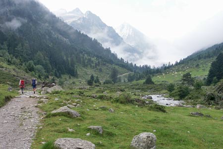
After parking follow the clear track upstream through pastures almost immediately crossing to east bank of the river. You should see cows grazing on this section. The path continues alongside the river climbing steadily crossing to the west bank after 3 kilometres. As you progress up the valley the surrounding scenery becomes more rugged and the mountains close in with Pic de la Sede (2976m) dominating the view ahead.
Like many glacial valleys the valley floor rises in steps and this is very much the case in the Lutour valley. Nearing the end of the walk you cross a flat area with the refuge just visible on a rocky ridge ahead. This final ascent complete, you are faced with a wonderful view ahead with Lac d'Estom providing a wonderful reflection of the mountains rising steeply on its far shore. The refuge lies to your left, strategically placed to prevent damage from avalanches and other catastrophes.
Lac d'Estom provides a perfect place to relax. If it is a busy day you can climb away from the area by the refuge to find your own private space to enjoy the view. The easiest way of doing this is to follow the path to the Refuge des Oulettes de Gaube. Relaxation complete, the return route is a gradual descent following the same path used for the ascent. Reaching the start at la Fruitière there is small hôtellerie offering meals and refreshments.
Suggested Maps
 - IGN Carte de Randonnée - Vignemalle - Ossau, Arrens, Cauterets - 1:25000 Sheet 1647OT
Stay Safe
Do enjoy yourself when out walking and choose a route that is within your capabilities especially with regard to navigation.
Do turn back if the weather deteriorates especially in winter or when visibility is poor.
Do wear the right clothing for the anticipated weather conditions. If the weather is likely to change for the worse make sure you have enough extra clothing in your pack.
Do tell someone where you are planning to walk especially in areas that see few other walkers.
Do take maps and other navigational aids. Do not rely on mobile devices in areas where reception is poor. Take spare batteries especially in cold weather.
Do check the weather forecast before leaving. The Met Office has a number of forecasts for walkers that identify specific weather risks.
Please Note - These walks have been published for use by site visitors on the understanding that Walking Britain is not held responsible for the safety or well being of those following the routes as described. It is worth reiterating the point that you should embark on a walk with the correct maps preferably at 1:25000 scale. This will enable any difficulties with route finding to be assessed and corrective action taken if necessary.