Refuge des Espuguettes & Cirque de Gavarnie
Walk 6049
Country - France
Region - Haute Pyrenees (65)
Author - Lou Johnson
Length - 10.0 km / 6.3 miles
Ascent - 653 metres / 2155 feet
Descent - 653 metres / 2155 feet
Grade - moderate
Click image to visit gallery of 12 images.
This walk provides a more interesting approach to the Cirque de Gavarnie by climbing high on the valley side before making a descent to the Hôtellerie du Cirque. The route is easy to navigate. However those with a dislike for steep drops on the side of the path might not like some sections of the route. These sections are noted in the description.
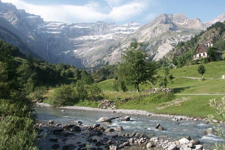
The start is the centre of the village where parking is available at a number of locations at varying prices including some free spaces at the northern end of the village. After parking walk south through the village and join the many visitors and mules heading along the direct path to the Cirque de Gavarnie. About 500 metres past the campsite a signed path to the Refuge des Espuguettes goes left.
Take this path and continue on the steady climb out of the valley. The path becomes a series of zigzags to reach a path junction on the Plateau de Pailla. Make a note of this junction as you will return here after visiting the Refuge. Turn left and follow the clear path as it makes a grand sweeping curve to reach the Refuge des Espuguettes, which can be seen well in advance.
After taking the view, which includes the Brèche de Roland, return to the junction noted above. You can of course turn right and return the way you came back to Gavarnie but the option described here is far more interesting and quite spectacular. Turn left and follow the path passing the Cabane de Pailla (refreshments in season). The way ahead is clear and soon you find yourself descending across a massive limestone cliff.
There are sections that need care. In places the limestone overhangs the path and the surface is quite slippery and wet. In others gullies across the path have eroded badly and the footholds are poor. However, with care and a steady nerve, all these obstacles can be overcome and the sensational location enjoyed to its full. Ahead is the Cirque de Gavarnie with its massive cliffs and numerous waterfalls. It is spectacular mountain scenery.
The path continues to descend and eventually arrives at the Hôtellerie du Cirque (refreshments in season). From here you can walk closer to the cliffs if you feel the need although when this route was researched it was rather disappointing having to share the view with so many people after having enjoyed the spectacular descent in solitude.
Whatever you do, the return to Gavarnie is straightforward. All you need to do is follow the many visitors and the occasional mule and rider back into the village. Despite having to share the path, the scenery is still superb and given sunny weather the walk back is still an enjoyable part of the walk.
Suggested Maps
 - IGN Carte de Randonnée - Gavarnie - Luz-St-Saveur - 1:25000 Sheet 1748OT
Stay Safe
Do enjoy yourself when out walking and choose a route that is within your capabilities especially with regard to navigation.
Do turn back if the weather deteriorates especially in winter or when visibility is poor.
Do wear the right clothing for the anticipated weather conditions. If the weather is likely to change for the worse make sure you have enough extra clothing in your pack.
Do tell someone where you are planning to walk especially in areas that see few other walkers.
Do take maps and other navigational aids. Do not rely on mobile devices in areas where reception is poor. Take spare batteries especially in cold weather.
Do check the weather forecast before leaving. The Met Office has a number of forecasts for walkers that identify specific weather risks.
Please Note - These walks have been published for use by site visitors on the understanding that Walking Britain is not held responsible for the safety or well being of those following the routes as described. It is worth reiterating the point that you should embark on a walk with the correct maps preferably at 1:25000 scale. This will enable any difficulties with route finding to be assessed and corrective action taken if necessary.