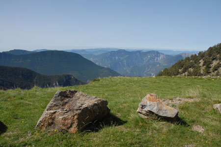
Col du Barn from Millefonts near Valdeblore
Walk 6053
Country - France
Region - Alpes-Maritimes (06) - Mercantour NP & Côte d'Azur
Author - Lou Johnson
Ascent - 470 metres / 1551 feet
Descent - 470 metres / 1551 feet
Time - 4.00 hours
Grade - moderate
Click image to visit gallery of 12 images.
This walk traverses open mountain grasslands that lie between Valdeblore and the Vesubie Valley. The route lies outside the Mercantour National Park but reaches the boundary at the Col du Barn (2452m) with superb views across the high mountain peaks that lie along the French-Italian border. The main summit in the vicinity is Mont Pépoiri (2674m) and an option to include this can be found in Walk 6054. The walk is best done between June and October although early and late season may see some lying snow that may obscure paths and make walking more difficult.
The start is located just over an hours drive from Nice. To reach the start you need to take an interesting mountain road from the D2565 between St-Dalmas-Valdeblore and St-Martin-Vesubie. On leaving St-Dalmas for Col St Martin, take the minor road on the left signed 'vacheries de Millefonts'. This road climbs in a series of spectacular traverses on the mountainside, and a number of hairpin bends, to reach a parking area at the end of the road at just over 2000 metres above sea level.
After parking walk back down the road a short way to sign no.82 (2030m) and turn left up the clear path (GR52), which rises through grassland to reach sign no.83 at the Col de Veillos (2194m). To the north east lie the grassy slopes of Mont Pépoiri whilst ahead is a broad valley that is the main focus of this walk.
From the Col de Veillos bear right (ignoring the descending path into the valley) and begin climbing again along a ridge on the GR52 signed Col de Barn. The path is always clear on the ground and you can expect some patches of snow even in late June. The way ahead passes through lovely rocky terrain following an undulating path. You soon reach Lac Long which is passed on your left. Continue on the main path gaining height steadily.
Lac Gros is the next landmark passed and this lies below the path on your right. Ahead you can see the main objective of the walk with Col de Barn in view. All that remains is to continue uphill until suddenly you are rewarded with a breathtaking panorama of the mountain in the Mercantour National Park.
The col is the perfect place to take a break, perhaps enjoying a picnic. The rest complete, retrace you steps down the outward route passing Lac Gros to arrive at Lac Long. Just past the end of this lake locate the feint path to the right of the main path that is marked with splashes of red paint. This leads down to Lac Rond. The onward route follows the stream exiting this lake to another lake where the path crosses the exit stream and drops down to fifth lake of this walk, namely Lac Petite. Despite its name this is the largest of the lakes!
The path skirts the northern and eastern shores to reach a small concrete dam at the outflow from the lake. Cross this and take the clear wide path that descends and then climbs up to the Col de Veillos, which was visited near the beginning of the walk. From here it is a short descent back to the car park.
Suggested Maps
 - IGN Carte de Randonnée - Vallée de la Vésubie Parc National du Mercantour - 1:25000 Sheet 3741OT
Stay Safe
Do enjoy yourself when out walking and choose a route that is within your capabilities especially with regard to navigation.
Do turn back if the weather deteriorates especially in winter or when visibility is poor.
Do wear the right clothing for the anticipated weather conditions. If the weather is likely to change for the worse make sure you have enough extra clothing in your pack.
Do tell someone where you are planning to walk especially in areas that see few other walkers.
Do take maps and other navigational aids. Do not rely on mobile devices in areas where reception is poor. Take spare batteries especially in cold weather.
Do check the weather forecast before leaving. The Met Office has a number of forecasts for walkers that identify specific weather risks.
Please Note - These walks have been published for use by site visitors on the understanding that Walking Britain is not held responsible for the safety or well being of those following the routes as described. It is worth reiterating the point that you should embark on a walk with the correct maps preferably at 1:25000 scale. This will enable any difficulties with route finding to be assessed and corrective action taken if necessary.