Lac de Prals (Cinq Lacs) from La Madone de Fenestre
Walk 6055
Country - France
Region - Alpes-Maritimes (06) - Mercantour NP & Côte d'Azur
Author - Lou Johnson
Ascent - 530 metres / 1749 feet
Descent - 530 metres / 1749 feet
Time - 4.00 hours
Grade - moderate
Click image to visit gallery of 12 images.
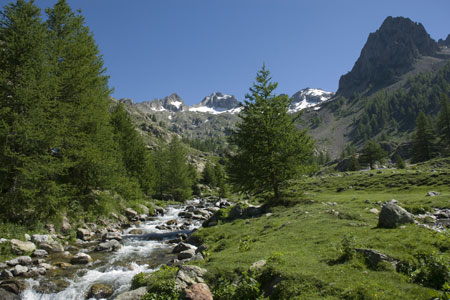
A pleasant mountain excursion, this walk traverses a variety of scenery from open upland grassland to mature forest. The start is located just over an hours drive from Nice. The Lacs de Prals are also refereed to as the 'Cinq Lacs' The start is below the Sanctuary of the Madonna at the end of the vallon de Fenestre, which is accessed by the D94 minor road from the regional centre of St-Martin-Vésubie. The walk can be undertaken between May and November although do expect some snow fields in early season especially in north facing locations. In late June 2008 there was still snow on the approach to the Baisse de Cinq Lacs.
The start is by footpath sign no.360 on the right hand side of the road less than a kilometre before the end of the road. Parking on the road is available just after crossing the river bridge. At busy times of the year it may be better to park back down the road near sign no.361 as you will return to this point at the end of the walk.
After parking continue along GR52 from sign no.360 with the river to your left. Pass the cowsheds (vacherie) on your right to reach sign no.359. Bear right here and continue on GR52 as far as sign no.367. Leave GR52 here and turn right. Almost immediately the path begins to climb using zigzags to gain height without too much hard work! As you gain height you pass through some open forest to arrive at the upper reaches of the Vallon du Ponset. The path gradient eases for a while heading south through this hanging valley before swinging in a long loop to gain a rocky ridge.
The final climb is steady and leads you to sign no.366 at the Baisse de Cinq Lacs. It is from here that you get your first view of the Lacs de Prals which are located below the dramatic rocky landscape of Mont Neiglier (2786m) that lies to the northeast of the lakes. The main path drops down and follows a line between the two right hand lakes. However you may wish to find your own quiet spot for lunch and a rest.
The descent proper starts now and follows the path between the two lakes mentioned above. It continues by following a rocky path across steep ground to enter a wide open area of grassland, Plan de Prals, with a sizeable population of Marmots who can be heard whistling their warnings as you descend. At sign no.364 turn right and begin the long steady descent down the Vallon des Prals back to the start.
Reaching sign no.363 continue straight ahead to enter a beautiful section of the valley with mature woodland, many wild flowers in season, and a crystal clear river that descends in a series of cascades downstream. It is like walking through a perfect rock garden. As progress is made, you cross the stream by a footbridge continuing on the west bank as far as sign no.362. Turn right here, re-cross the river and follow the path, which soon arrives back at the road (sign no.361). Turn right up the road back to the start.
Note - this walk is often described in reverse. However the route as described, going clockwise, means you cover the steeper ground generally in ascent using zigzags on a well graded path with the descent gently graded and causing less damage to your knees. If you go clockwise the ascent is steady and long with a knee-jarring descent down to sign no.367 at the end of the day.
Suggested Maps
 - IGN Carte de Randonnée - Vallée de la Vésubie Parc National du Mercantour - 1:25000 Sheet 3741OT
Stay Safe
Do enjoy yourself when out walking and choose a route that is within your capabilities especially with regard to navigation.
Do turn back if the weather deteriorates especially in winter or when visibility is poor.
Do wear the right clothing for the anticipated weather conditions. If the weather is likely to change for the worse make sure you have enough extra clothing in your pack.
Do tell someone where you are planning to walk especially in areas that see few other walkers.
Do take maps and other navigational aids. Do not rely on mobile devices in areas where reception is poor. Take spare batteries especially in cold weather.
Do check the weather forecast before leaving. The Met Office has a number of forecasts for walkers that identify specific weather risks.
Please Note - These walks have been published for use by site visitors on the understanding that Walking Britain is not held responsible for the safety or well being of those following the routes as described. It is worth reiterating the point that you should embark on a walk with the correct maps preferably at 1:25000 scale. This will enable any difficulties with route finding to be assessed and corrective action taken if necessary.