Tunnel Mountain from Banff
Walk 6062
Country - Canada
Region - Banff National Park
Author - Lou Johnson
Length - 4.3 km / 2.7 miles
Ascent - 300 metres / 990 feet
Descent - 300 metres / 990 feet
Time - 2.00 hours
Grade - easy
Click image to visit gallery of 6 images.
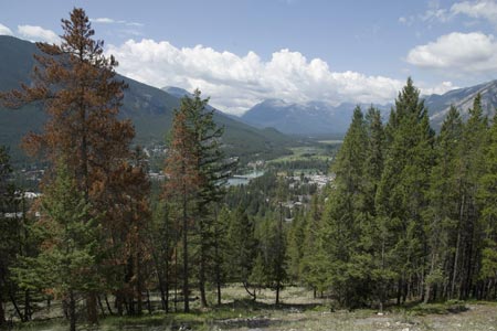
Tunnel Mountain is a popular short hike from the centre of Banff and offers excellent views along the valley in both directions together with some wonderful panoramas of the mountain peaks in the vicinity of Banff.
To gain the trail go east on Wolf Street and then right into St Julien Road. The start of the path starts on your left by a rough parking area on the same side of the road. The path climbs steadily in zigzags through typical fir and pine forest. You gain elevation easily and soon reach Tunnel Mountain Drive where there is another parking area if you wish to shorten the walk by starting higher.
Cross the road and continue to follow the well maintained path as it climbs in more zigzags towards the summit. As you near the top you get excellent views of Mount Rundle, great views in either direction along the valley and a bird's eye view of Banff town. The summit area is quite open and makes a perfect spot for a picnic.
To return to the start retrace your steps down the hill.
Notes For those without their own transport, walking from the downtown area adds very little distance to the hike. Also that once on the trail there are no refreshments or water sources.
Suggested Maps
 - Government of Canada Topographic Map, Sheet 82O/04 - Banff, 1:50000 scale
Stay Safe
Do enjoy yourself when out walking and choose a route that is within your capabilities especially with regard to navigation.
Do turn back if the weather deteriorates especially in winter or when visibility is poor.
Do wear the right clothing for the anticipated weather conditions. If the weather is likely to change for the worse make sure you have enough extra clothing in your pack.
Do tell someone where you are planning to walk especially in areas that see few other walkers.
Do take maps and other navigational aids. Do not rely on mobile devices in areas where reception is poor. Take spare batteries especially in cold weather.
Do check the weather forecast before leaving. The Met Office has a number of forecasts for walkers that identify specific weather risks.
Please Note - These walks have been published for use by site visitors on the understanding that Walking Britain is not held responsible for the safety or well being of those following the routes as described. It is worth reiterating the point that you should embark on a walk with the correct maps preferably at 1:25000 scale. This will enable any difficulties with route finding to be assessed and corrective action taken if necessary.