Lake Agnes Tea House from Lake Louise
Walk 6063
Country - Canada
Region - Banff National Park
Author - Lou Johnson
Length - 6.8 km / 4.3 miles
Ascent - 385 metres / 1271 feet
Descent - 385 metres / 1271 feet
Time - 2.50 hours
Grade - easy/mod
Click image to visit gallery of 9 images.
This attractive walk gets you into the mountains and away from the many visitors that Lake Louise attracts each year. The going is generally easy with a well maintained trail rising steadily through forest. There is one short section where the uphill work is a little harder but this is near the teahouse so you have plenty of reasons for not slowing down!
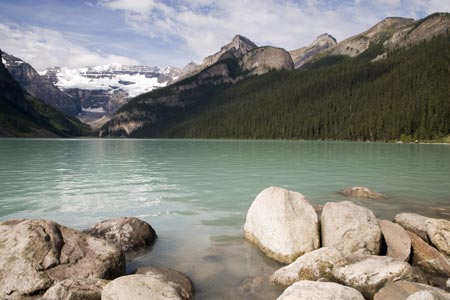
From the main parking lot for Lake Louise, walk down past the toilets to gain the lakeshore. You will find this thronged by many visitors all enjoying the magnificent view that makes this location famous across the world. Continue along the shoreline trail with Chateau lake Louise on your right. There are many boards providing a range of information about the area and its wildlife.
Continue along the shoreline trail for a short way and when you are level with the end block of the hotel look out for the signed trail to Lake Agnes and Teahouse. Take this path climbing away from the lakeshore trail into forest. There are few views to distract your upward progress although you will get glimpses of the lake and be able to enjoy the mountains rising above the trees.
The path doubles back on itself in a loop and continues to climb. Meeting the horse trail at a wooden barrier the trail turns left and soon reaches Mirror Lake, which nestles below the 'Big Beehive'. Continue upward with a short steeper section to reach some wooden stairs. Climb these and you will arrive below the teahouse with a splendid view of Lake Agnes and its protecting backdrop of mountains.
The teahouse offers a range of drinks and eats and is only open in the summer. Besides a steady line of hikers it also attracts a sizeable colony of Chipmunks who you are asked not to feed.
The return route follows the outward trail. However there are two additional options from the teahouse. The 'Big Beehive' adds another 3 km roundtrip and involves a further 135 metres of ascent. It smaller sibling, the 'Little Beehive' can also be climbed and this adds another 100 metres of ascent and around 2 km extra walking. Both of these trails start near the teahouse and are well signed.
Suggested Maps
 - Government of Canada Topographic Map, Sheet 82N/08 - Lake Louise, 1:50000 scale
Stay Safe
Do enjoy yourself when out walking and choose a route that is within your capabilities especially with regard to navigation.
Do turn back if the weather deteriorates especially in winter or when visibility is poor.
Do wear the right clothing for the anticipated weather conditions. If the weather is likely to change for the worse make sure you have enough extra clothing in your pack.
Do tell someone where you are planning to walk especially in areas that see few other walkers.
Do take maps and other navigational aids. Do not rely on mobile devices in areas where reception is poor. Take spare batteries especially in cold weather.
Do check the weather forecast before leaving. The Met Office has a number of forecasts for walkers that identify specific weather risks.
Please Note - These walks have been published for use by site visitors on the understanding that Walking Britain is not held responsible for the safety or well being of those following the routes as described. It is worth reiterating the point that you should embark on a walk with the correct maps preferably at 1:25000 scale. This will enable any difficulties with route finding to be assessed and corrective action taken if necessary.