The Cavell Meadows Trail
Walk 6068
Country - Canada
Region - Jasper National Park
Author - Lou Johnson
Ascent - 400 metres / 1320 feet
Descent - 400 metres / 1320 feet
Time - 3.00 hours
Grade - easy/mod
Click image to visit gallery of 9 images.
This walk takes you about 400 metres above the trailhead car park and the reward is some good views of the Angel Glacier, some colourful wild flower meadows and longer views of the area. The start is the car park at the end of Cavell Road. To reach here take Highway 93 for about 7km south of Jasper and turn right onto Highway 93A. Continue for just over 5km and then turn right again onto Cavell Road. This 12km section is narrow and quite slow in places. At busy times parking spaces at the trailhead may be in short supply. Also note that the trail may be closed until mid-July.
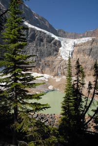
From the far end of the parking area take the short flight of steps up onto the paved trail and start to climb along the crest of the moraine. On this section you get fine views across the valley to the Angel Glacier with Mount Edith Cavell to its left and Sorrow Peak to the right. Reaching a path junction just after the end of the paved section, turn sharp left and continue climbing through pines. It is important to stay on marked trails as you are crossing very delicate tundra.
After the first major viewpoint, you reach a trail junction. Keeping right takes you to the lower viewpoint in the meadows whilst bearing left will take you much higher to a rocky outlook above the meadows. The lower viewpoint offers excellent views across to the Angel Glacier and it is interesting to see the contrast in vegetation from where you are standing to the austere rocky environment only a short way across the valley. The higher viewpoint can also be reached by a cross trail from the lower viewpoint and offers wider panoramas of the area in general together with views of the Angel Glacier.
Return to the parking lot is by the same trail used for the uphill hike. However reaching the junction near the end of the paved path, you can turn left to follow the Glacier Loop before returning to your transport.
Stay Safe
Do enjoy yourself when out walking and choose a route that is within your capabilities especially with regard to navigation.
Do turn back if the weather deteriorates especially in winter or when visibility is poor.
Do wear the right clothing for the anticipated weather conditions. If the weather is likely to change for the worse make sure you have enough extra clothing in your pack.
Do tell someone where you are planning to walk especially in areas that see few other walkers.
Do take maps and other navigational aids. Do not rely on mobile devices in areas where reception is poor. Take spare batteries especially in cold weather.
Do check the weather forecast before leaving. The Met Office has a number of forecasts for walkers that identify specific weather risks.
Please Note - These walks have been published for use by site visitors on the understanding that Walking Britain is not held responsible for the safety or well being of those following the routes as described. It is worth reiterating the point that you should embark on a walk with the correct maps preferably at 1:25000 scale. This will enable any difficulties with route finding to be assessed and corrective action taken if necessary.