Lac des Vache & Refuge du Col de la Vanoise from Pralognan
Walk 6070
Country - France
Region - Savoie (73) - Vanoise National Park
Author - Lou Johnson
Ascent - 530 metres / 1749 feet
Descent - 530 metres / 1749 feet
Time - 4.00 hours
Grade - moderate
Click image to visit gallery of 12 images.
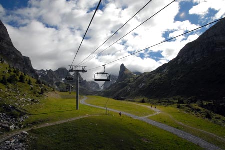
This walk takes you into the high mountains amongst some very rugged scenery and is probably the most spectacular walk in the vicinity of Pralognan. The route takes you past the foot of the Grande Casse (3855m), the highest peak in the Vanoise National Park. Underfoot the path is generally stony and good footwear is recommended. The walk as described is dependent on the chairlift operating to the Pont de la Gliere. In summer this is two days per week. For alternatives see the end of the walk description.
Take the twisting road up from the centre of Pralognan to les Fontanettes, the lower station of the chairlift. There is ample free parking available. The chairlift provides an easy ascent of just over 300 metres and deposits you at the Pont de la Gliere. Cross the bridge and take the wide path contained in stone walls heading up the valley. On your right is the impressive slab of rock forming the Aiguille de la Vanoise (2797m).
The initially climbs steadily but soon follows a series of zigzags as the way gets steeper. Arrival at the Lac des Vaches is something of a surprise as you suddenly see it ahead. The lake is not very deep and is crossed by means of stepping stones. Ahead you will no doubt see other walkers on the path as they ascend through a rocky amphitheatre. At some point on this section you should see Grande Casse (it was topped in cloud when I walked this route).
The going is quite steep in places and there are a couple of sections where the path is annoyingly stony. However despite these irritations you soon arrive above Lac Long. Once this is reached the final section of path to the Refuge is quite straightforward and all the hard work has been done. This walk is busy on days when the chairlift is in operation and consequently the refuge is operating at full capacity during the lunchtime period so you may have to wait a little for food and drinks.
The return route follows the outward walk so you are able to enjoy the scenery from a different angle on the way down. Wildlife is to be seen with Marmottes spotted quite frequently during the walk. In addition a group of Ibex were seen near the Refuge.
On days when the chairlift is not operating you have two choices. The first is to park at Les Fontanettes and start and end the walk there. This adds about 330 metres of ascent and perhaps two hours extra walking time. The second option is to use the cable car from the centre of Pralognan to Mont Bochor from where there is a path to Pont de la Gliere. However there is the problem with limited departures of the cable car especially in the late afternoon.
Suggested Maps
 - IGN Carte de Randonnée - Les Trois Vallees & Modane, Parc National de la Vanoise - 1:25000 Sheet 3534 OT
Stay Safe
Do enjoy yourself when out walking and choose a route that is within your capabilities especially with regard to navigation.
Do turn back if the weather deteriorates especially in winter or when visibility is poor.
Do wear the right clothing for the anticipated weather conditions. If the weather is likely to change for the worse make sure you have enough extra clothing in your pack.
Do tell someone where you are planning to walk especially in areas that see few other walkers.
Do take maps and other navigational aids. Do not rely on mobile devices in areas where reception is poor. Take spare batteries especially in cold weather.
Do check the weather forecast before leaving. The Met Office has a number of forecasts for walkers that identify specific weather risks.
Please Note - These walks have been published for use by site visitors on the understanding that Walking Britain is not held responsible for the safety or well being of those following the routes as described. It is worth reiterating the point that you should embark on a walk with the correct maps preferably at 1:25000 scale. This will enable any difficulties with route finding to be assessed and corrective action taken if necessary.