Pralognan to la Croix
Walk 6071
Country - France
Region - Savoie (73) - Vanoise National Park
Author - Lou Johnson
Ascent - 150 metres / 495 feet
Descent - 150 metres / 495 feet
Time - 2.00 hours
Grade - easy
Click image to visit gallery of 9 images.
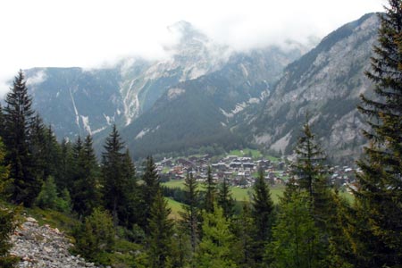
This short walk is ideal for an evening stroll or for those days when visibility in the mountains is poor due to low cloud or rain. There are some uphill sections that provide some welcome exercise and the views are good. The small village of la Croix still retains some character although note that there are no sources of refreshment.
The start is the market square in the centre of Pralognan. From here take the main road following the one-way traffic out of town into Avenue de la Grande Casse. Turn left into Cote du Plan and follow this narrow street uphill between houses to a main road. Cross the road to the bust stop and take the signed footpath that leads uphill into woodland.
You are now on the path to la Croix. The path is signed and clearly marked on the suggested map. After climbing for some minutes you reach the first path junction. Go straight ahead and continue to Beauregard. Here the path forks. Take the right fork and continue to la Croix descending quite steeply as the village is reached.
Despite some evidence of modernisation, the houses in the village still retain their character. Narrow streets and a village pump all add character to the scene. After exploring the village retrace your steps back to Pralognan.
Suggested Maps
 - IGN Carte de Randonnée - Les Trois Vallees & Modane, Parc National de la Vanoise - 1:25000 Sheet 3534 OT
Stay Safe
Do enjoy yourself when out walking and choose a route that is within your capabilities especially with regard to navigation.
Do turn back if the weather deteriorates especially in winter or when visibility is poor.
Do wear the right clothing for the anticipated weather conditions. If the weather is likely to change for the worse make sure you have enough extra clothing in your pack.
Do tell someone where you are planning to walk especially in areas that see few other walkers.
Do take maps and other navigational aids. Do not rely on mobile devices in areas where reception is poor. Take spare batteries especially in cold weather.
Do check the weather forecast before leaving. The Met Office has a number of forecasts for walkers that identify specific weather risks.
Please Note - These walks have been published for use by site visitors on the understanding that Walking Britain is not held responsible for the safety or well being of those following the routes as described. It is worth reiterating the point that you should embark on a walk with the correct maps preferably at 1:25000 scale. This will enable any difficulties with route finding to be assessed and corrective action taken if necessary.