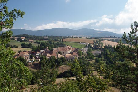
St Martin-de-Clelles & Darne Viaduct from Clelles
Walk 6078
Country - France
Region - Isere (38) - Parc Naturel Régional du Vercors
Author - Lou Johnson
Length - 12.0 km / 7.5 miles
Ascent - 300 metres / 990 feet
Descent - 300 metres / 990 feet
Grade - easy/mod
Click image to visit gallery of 9 images.
The commune of Clelles lies just off the N75 main road from Grenoble to Veynes. There are many attractive villages in the area together with the impressive limestone scenery of the Vercors to the west and some wonderful views to the western fringes of the Ecrins National Park in the east. The walking between villages is mainly along tracks using some short sections of public roads which are generally very quiet.
This walk starts in the centre of the village where meals and refreshments are available. From the central square follow the road north out of the village leading to the N75 main road. After about 100 metres turn right down the signed path. At a path junction by the Malverger Cross go straight ahead. Descend slightly to cross a stream and reach another path junction where you go straight ahead. The path continues through woodland to reach the Pont de Chardon, which is the lowest point of the walk. Climb away from the river to reach the tarmac road at the entrance of St-Martin-de-Clelles. The village is on the right and worth a look.
However the walk continues by turning left just prior to the road and continues in a loop to pass Beyllloux to cross the main N75 and climb up to Chalabaud. Here you should ignore the path to Thoranne and continue straight on. The path is now passing through woodland above the railway line to reach a path junction at Au Fontaniou. Turn left here and go under the Darne Viaduct before doubling back under the viaduct again to reach Bois des Chaux. Turn left to La Genie and after 200 metres continue ahead to Le Chaffaud where you cross the N75 again. Turn right at the next junction for Oratoire and this will lead to the Malverger Cross. Turn right and within a few minutes you are back in the village of Clelles.
Suggested Maps
 - IGN Carte de Randonnée - Glandasse, Col de ka Croix-haute, PNR du Vercors - 1:25000 Sheet 3237 OT
- Promenades et Randonnees - Le Trieves: Autour de Clelles. Available in the excellent Tourist Office in Clelles.
Stay Safe
Do enjoy yourself when out walking and choose a route that is within your capabilities especially with regard to navigation.
Do turn back if the weather deteriorates especially in winter or when visibility is poor.
Do wear the right clothing for the anticipated weather conditions. If the weather is likely to change for the worse make sure you have enough extra clothing in your pack.
Do tell someone where you are planning to walk especially in areas that see few other walkers.
Do take maps and other navigational aids. Do not rely on mobile devices in areas where reception is poor. Take spare batteries especially in cold weather.
Do check the weather forecast before leaving. The Met Office has a number of forecasts for walkers that identify specific weather risks.
Please Note - These walks have been published for use by site visitors on the understanding that Walking Britain is not held responsible for the safety or well being of those following the routes as described. It is worth reiterating the point that you should embark on a walk with the correct maps preferably at 1:25000 scale. This will enable any difficulties with route finding to be assessed and corrective action taken if necessary.