A circuit of Eibsee near Garmisch-Partenkirchen
Walk 6090
Country - Germany
Region - Bavarian Alps - Garmisch-Partenkirchen
Author - Lou Johnson
Length - 8.0 km / 5 miles
Time - 2.00 hours
Grade - easy
Click image to visit gallery of 9 images.
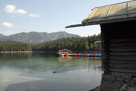
Eibsee is a beautiful lake that lies on the northern flank of the Zugspitze, the highest mountain in Germany at 2962 metres. The walk is generally easy and navigation is not problematic as all you need do is follow the shore of the lake in a clockwise direction.
The start is the large car park at the valley station of the Eibsee Seilbahn, the cable car that takes you to the summit of the Zugspitze. This can easily reached by road or alternatively you can arrive by one of the regular trains on the Zugspitzbahn from Garmisch-Partenkirchen.
Leave the car park and walk down towards the Eibsee. There are a number of shops and restaurants here. Note that there are no more opportunities for refreshment until you return here at the end of the walk. After a few minutes you will arrive at the shore. The walk follows the main path around the lake in a clockwise direction. The main path is easy to find and you should have the lake on your right hand side. The path does have some steady climbs and you will find yourself well above the lake for parts of the walk. However none of the climbs is steep or too long.
The lake occupies a pleasant position with most of the surrounding hillsides covered with woodland. However this does provide shade for much of the walk and does not detract from the views which in the first part of the walk look across the lake to a range of rolling hills. Once you have reached the northern shore you have clear views of the Zugspitze.
On the northern shores of the lake there are two path junctions. At the first go straight ahead, ignoring the path going left. At the second junction reached after crossing an inlet you must turn right again ignoring the path to the left. You will soon be back at the start.
Suggested Maps
 - Garmisch-Partenkirchen - 1:25000 scale - sheet WK D 4 published by Freytag & Berndt
Stay Safe
Do enjoy yourself when out walking and choose a route that is within your capabilities especially with regard to navigation.
Do turn back if the weather deteriorates especially in winter or when visibility is poor.
Do wear the right clothing for the anticipated weather conditions. If the weather is likely to change for the worse make sure you have enough extra clothing in your pack.
Do tell someone where you are planning to walk especially in areas that see few other walkers.
Do take maps and other navigational aids. Do not rely on mobile devices in areas where reception is poor. Take spare batteries especially in cold weather.
Do check the weather forecast before leaving. The Met Office has a number of forecasts for walkers that identify specific weather risks.
Please Note - These walks have been published for use by site visitors on the understanding that Walking Britain is not held responsible for the safety or well being of those following the routes as described. It is worth reiterating the point that you should embark on a walk with the correct maps preferably at 1:25000 scale. This will enable any difficulties with route finding to be assessed and corrective action taken if necessary.