Delphi to the Korycian Cave - Parnassos
Walk 6102
Country - Greece
Author - Paul Webb
Length - 18.0 km / 11.3 miles
Ascent - 700 metres / 2310 feet
Descent - 700 metres / 2310 feet
Grade - mod/hard
Click image to visit gallery of 6 images.
For those visiting the beautiful remains of the Sanctuary of Apollo at Delphi, who want to spend a day away from the crowds and experience some of the mystery of classical Greece along with stunning views, take this walk up into the Parnassos mountains to the Korycian Cave. This takes an ancient route followed by worshippers of Pan and also by convicts who were thrown to their death from the high pinnacles towering above the ancient site of the Oracle. (Picture 610201)
Start from the eastern end of the village of Delphi. By a kiosk (where you may purchase a map) in the fork of the main streets, is an information board Grid ref. 368700/4259600. Take the path north up the steps. Turn right onto the small road and follow almost to its end as it climbs to the boundary fence of the ancient site with excellent view of the Stadium (Picture 610202).
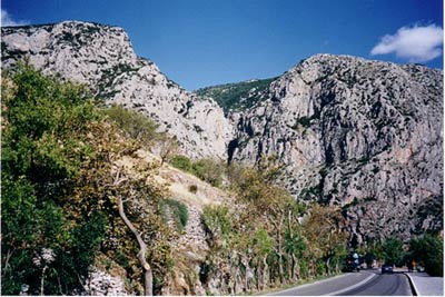
To the left of the road you will pick out the yellow and black E4 markers of the European long distance trail. which you follow up a fairly steep slope through the rock and scrub to the start of a cobbled, well made path which zig-zags its way up into the mountain. These are the "Kaki Skala" (evil steps). As you quickly gain height above the village, wonderful views open out southwards over the steep valleys and the plain towards Itea, the Gulf of Corinth and the mountains of the Peloponnese in the distance (Picture 610203 and 610204). About 2.5 Km from the start of the walk the path levels out into a pass north through the pinnacles towards Kroki. The path follows the water conduit which supplies Delphi and is easily navigated with the trail markers and the large concrete manholes for the conduit. Sheep and cattle graze the hillsides around. As you lose the views to the south, those of the Parnassos range open up to the north and east.
Passing a farm up on the hill to your left (beware the farm dogs!), carry on until a rough road crosses your path and turn right onto this road by some sheep pens. You have now left the E4 trail but there are helpful red square trail markers for the rest of the route. 50m east along the road just past a fork in the road, a footpath takes the route of the old forest road for about 2.5 km through firs and cypresses eventually joining the valleys of streams which feed the Castillian Spring of the Delphi ancient site.
Turn right when the path joins the metalled road again for 1Km through the wooded picnic areas to the small church at Panaghia. There is also a forest ranger's lodge here. (Grid ref. 370200/4263500) (Picture 610205)
The Korycian Cave is up the hill behind the church and you can choose either the path which climbs the hill directly to the right of the church or walk about 0.75Km further east along the road where a better marked path leads off from the left. The former starts very well defined but peters out after a while and map and compass may be required to avoid overshooting the entrance to the cave and heading off up towards the summit of Paliovouna.
The cave entrance (Grid ref. 371000/4263800) lies at the end of a road which does bring a few visitors in cars. If you are lucky enough to arrive without such company you will enjoy even more the atmosphere of this ancient gathering place. (Picture 610206) Beyond the mouth of the cave lies a spectacular cavern about 60 metres in length, with stalagmites and stalactites and inscriptions on the walls (ancient and modern). The cave apparently goes a further 600 metres into the mountain but is not navigable without lighting and specialist equipment.
Having spent as much time as you can afford, retrace your route to Delphi.
The top plains and mountains are part of the Parnasosos skiing areas. We took the route at the end of October, out of the skiing season.
(As a fairly lengthy alternative, we chose to cross the beautiful and peaceful plain of Livadhi Arahovas by dirt road towards Stavros and thence down the hairpin bends to spend some time in the lovely mountain town of Arahova.)
Suggested Maps
 - Anavasi Topo 25 - Central Parnassos 1:25,000
Stay Safe
Do enjoy yourself when out walking and choose a route that is within your capabilities especially with regard to navigation.
Do turn back if the weather deteriorates especially in winter or when visibility is poor.
Do wear the right clothing for the anticipated weather conditions. If the weather is likely to change for the worse make sure you have enough extra clothing in your pack.
Do tell someone where you are planning to walk especially in areas that see few other walkers.
Do take maps and other navigational aids. Do not rely on mobile devices in areas where reception is poor. Take spare batteries especially in cold weather.
Do check the weather forecast before leaving. The Met Office has a number of forecasts for walkers that identify specific weather risks.
Please Note - These walks have been published for use by site visitors on the understanding that Walking Britain is not held responsible for the safety or well being of those following the routes as described. It is worth reiterating the point that you should embark on a walk with the correct maps preferably at 1:25000 scale. This will enable any difficulties with route finding to be assessed and corrective action taken if necessary.