Gilillo - Sierra de Cazorla
Walk 6106
Country - Spain
Region - Jaen Province (Andalucia)
Author - Paul Webb
Length - 18.0 km / 11.3 miles
Ascent - 1065 metres / 3515 feet
Grade - mod/hard
Click image to visit gallery of 9 images.
The Sierra de Cazorla lies approximately 100 Km NE of Granada inside the Parque Natural de Cazorla, Segura Y Las Villas. It is a fascinating and beautiful area offering superb walking and abundant flora and fauna.
We took this walk in early March 2004 when the snows above 1300m were just thawing. The days were hot and sunny and the nights sub zero. We camped at the Camping San Isicio, (1.5Km SW of the town of Cazorla) a peaceful site whose charming owners are sympathetic and helpful to walkers and can provide maps and route plans.
Map references are from Editorial Alpina Tourist & Hiker's Map 1:40,000 "Sierra de Cazorla" ( www.editorialalpina.com ). Other useful guidance from Lonely Planet "Walking In Spain".
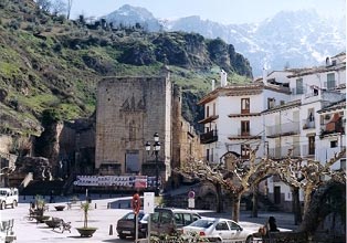
Start from the Plaza de Santa Maria in Cazorla (photo 610601) and head west along the Camino de San Isicio behind the fountain. 250m up the road, fork left up a track marked with a red & white trail marker. This track leads you up and to the left of the church of San Isicio. 750m further on, take a zig zag up to your left onto a path carrying you under the higher castle Castillo de Cinco Esquinas. The views across the massive olive plains of Jaen open up to the west (photo 610602). The path climbs through olive groves and past hunting shelters to the Monastery de Monte Sion. If you are lucky enough to meet the monk who looks after the monastery he will be pleased to explain his work there and the festivals celebrated (in Spanish) (photo 610603).
Take the path through the woods SSE which winds and climbs steadily to a dirt road. Cross the road and a few metres down the road to the right a path (photo 610604) goes up to the left and into the woods again 400m towards Collado de Cagahierro. Here another path joins from the left. Continue right (SSE) and stay on this path (photo 610605) getting narrower and steeper right up to the col at Puerto Gilillo about 1.5 Km.
At Puerto Gillio (1700m) (photos 610606, 610607, 610608) you can really appreciate the views to the east across the valley of the infant Rio Guadalquivir, and may be lucky enough to witness the birds of prey soaring on the wind currents up the side of the mountain.
The Summit of Gilillio (1848m) can be reached with a climb of 150m by a clear path south from the col.
The map and Lonely Planet guide offers a walk north from here along the ridge to La Lagunilla but on this occasion the path was too obscured with snow and we decided to retrace our steps (photo 610609) to the dirt road and then north via Riogazas and La Iruela to Cazorla town - a long but extremely pleasant gentle descent with views over the town in the evening sun.
Suggested Maps
 - Editorial Alpina Tourist & Hiker's Map 1:40,000 "Sierra de Cazorla"
Stay Safe
Do enjoy yourself when out walking and choose a route that is within your capabilities especially with regard to navigation.
Do turn back if the weather deteriorates especially in winter or when visibility is poor.
Do wear the right clothing for the anticipated weather conditions. If the weather is likely to change for the worse make sure you have enough extra clothing in your pack.
Do tell someone where you are planning to walk especially in areas that see few other walkers.
Do take maps and other navigational aids. Do not rely on mobile devices in areas where reception is poor. Take spare batteries especially in cold weather.
Do check the weather forecast before leaving. The Met Office has a number of forecasts for walkers that identify specific weather risks.
Please Note - These walks have been published for use by site visitors on the understanding that Walking Britain is not held responsible for the safety or well being of those following the routes as described. It is worth reiterating the point that you should embark on a walk with the correct maps preferably at 1:25000 scale. This will enable any difficulties with route finding to be assessed and corrective action taken if necessary.