Rio Borosa Valley
Walk 6107
Country - Spain
Region - Jaen Province (Andalucia)
Author - Paul Webb
Length - 22.0 km / 13.8 miles
Ascent - 550 metres / 1815 feet
Grade - mod/hard
Click image to visit gallery of 9 images.
The Sierra de Cazorla lies approximately 100 Km NE of Granada inside the Parque Natural de Cazorla, Segura Y Las Villas. It is a fascinating and beautiful area offering superb walking and abundant flora and fauna. This is a fairly long but not too strenuous walk requiring little navigational skill. Each stage rewards the walker with a new aspect of the beautiful river valley right up to its source and two wonderful lakes beyond. It is an unforgettable classic walk of the area.
We took this walk in early March 2004 when the snows above 1300m were just thawing. The days were hot and sunny and the nights sub zero. We camped at the Camping San Isicio, (1.5Km SW of the town of Cazorla) a peaceful site whose charming owners are sympathetic and helpful to walkers and can provide maps and route plans.
Map references are from Editorial Alpina Tourist & Hiker's Map 1:40,000 "Sierra de Cazorla" (www.editorialalpina.com). Other useful guidance from Lonely Planet "Walking In Spain".
The start is about 1 hour drive north from Cazorla on the A319. The drive down the Guadalquivir valley close to the source of the river which ends up in the Atlantic Ocean is an experience in itself.
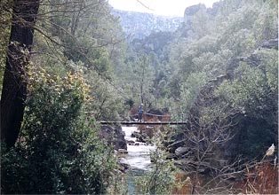
Start from the car park at the information centre near the Piscifactoria (Grid Ref. 2º:51'30" / 38º01'0") about 1Km from the bus stop and junction with the A319. Head east across the bridge at the Piscifactoria and immediately right onto a dirt road signposted Rio Borosa. You pass along the lower slopes of the abundant trout fishing river and a short way along a path forks off to the left for the climb to the peaks of the Cordillera de las Banderillas. Your route however stays on the dirt road (which crosses the river twice - be careful not to take the road off to the right at Puente de los Caracollos) (photo 610701). At 3.5 Km from the start there is a sign on the right onto a path marked Cerrada de Elias. This deviation from the road follows the river's course with a delightful set of wooden walkways a couple of meters above the river, eventually rejoining the road.(photo 610702)
The road gently climbs up the valley as the fishing signs change to "Coto sin muerte" (no killing) and finally "Non Coto2. The river runs with plenty of water over these higher reaches until you meet the next delight which is the cutest hydro-electric power station you have ever seen, just over a bridge (photo 610704). You will see the pipeline coming down from a canal high up in the gorge and the reason for the much reduced water flow in the river from here upwards. The path runs to the right of the power station and becomes a bit more steep and rugged.
A decent climb takes you up into almost a Chinese landscape as the mountain of Picon del Haza rises vertically on your left. (photos610703 & 610705) The rocks are well eroded and there are several warnings about rockfalls. At the head of this part of the valley you will come upon the waterfall which is somewhat depleted by the transfer of water to the power station and then a series of zig zags lead you up alongside the almost sheer rockface to meet the small canal that feeds the power station.
Here you follow an exciting path along two tunnels at the side of the canal 140m above the waterfall. The tunnels have some openings in the rock face to allow in light and provide views, but are in part fairly dark and low (a torch is useful in these sections). (photos 610706 & 610707)
Emerging from the second tunnel you are at the dam and reservoir Embalse de Aguas Negras (photo 007h). 500m up a path to your left is the source of the Rio Borosa. To the right of the reservoir, the path leads through woods about 1Km further up to the natural lake Laguna de Valdeazores (photo 610708)and the end of the outward leg of the walk.
Retrace the route to the start after savouring the clear mountain air and views of the mountains reflected in the blue waters of the lakes.
Suggested Maps
 - Editorial Alpina Tourist & Hiker's Map 1:40,000 "Sierra de Cazorla"
Stay Safe
Do enjoy yourself when out walking and choose a route that is within your capabilities especially with regard to navigation.
Do turn back if the weather deteriorates especially in winter or when visibility is poor.
Do wear the right clothing for the anticipated weather conditions. If the weather is likely to change for the worse make sure you have enough extra clothing in your pack.
Do tell someone where you are planning to walk especially in areas that see few other walkers.
Do take maps and other navigational aids. Do not rely on mobile devices in areas where reception is poor. Take spare batteries especially in cold weather.
Do check the weather forecast before leaving. The Met Office has a number of forecasts for walkers that identify specific weather risks.
Please Note - These walks have been published for use by site visitors on the understanding that Walking Britain is not held responsible for the safety or well being of those following the routes as described. It is worth reiterating the point that you should embark on a walk with the correct maps preferably at 1:25000 scale. This will enable any difficulties with route finding to be assessed and corrective action taken if necessary.