Rio Cares Gorge
Walk 6110
Country - Spain
Region - Picos de Europa
Author - Paul Webb
Length - 20.0 km / 12.5 miles
Ascent - 600 metres / 1980 feet
Grade - moderate
Click image to visit gallery of 11 images.
The Picos De Europa of Northern Spain are a delightful and relatively quiet range offering many high and lower level walks, unforgettable for the scenery, flora, fauna and charming villages where life appears to be little unchanged by the wonders of modern technology. There was still snow on the upper walks in April but this one is usually unaffected. Local Parque Nacional information boards advise of any hazards.
This is a classic gorge walk without too much uphill work, on good paths, requiring little navigation; so it's easy to enjoy the spectacular views to the full.
An excellent guide is "Picos De Europa" by Teresa Farino (Sunflower Books www.sunflowerbooks.co.uk ). Also useful is the Lonely Planet: "Walking in Spain". Essential Maps are by Adrados Ediciones : "El Cornion" and "Los Urrieles y Andara" at 1:25000, and there is also a useful 1:40,000 map of the whole of the Picos.
Start the walk from the car park at Puente Poncebos on the AS264. Here you look down to the hydroelectric power station fed by the canal which you will follow up the gorge. Here also is the funicular which whisks the sedentary quickly up the mountain to Bulnes.
Take the metalled road to the SW which changes to a limestone track after 600m, well signposted "Ruta del Cares". Stay on the main path throughout as paths diverge to the right to Comidas and to the left to Bulnes.
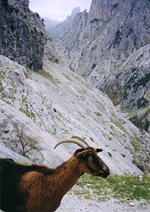
The track now climbs approx 250m (photo v010b)and is the only real uphill stretch of the outward stretch. As you climb, the Rio Cares slips away from you forming a deeper and deeper valley, and the view gets better and better. You will probably be met by goats (photo 611001) as the path reaches the level of the canal by some barns (photo 611003). About 15 minutes later you reach the highest point of this part, and on your right are the barns of Los Collados.
The path winds downwards again (photo 611004 & photo 611005) to return to the canal and then mostly contours the mountainside. Rock arches have been cut to ensure easy passage (photo 611006 & photo 611007).
As you reach Culiembro, the gorge narrows and you pass over and under tributaries on the way to the first bridge Puente Bolin (photo 611008). Make sure you have camera ready. The bridge is of sturdy "box" construction and provides wonderful views as you cross the river at great height. Five minutes later you cross the second bridge, Puente de los Rebecos (photo 611009) and then enter a tunnel carved from the rock. The tunnel has side openings letting in daylight, but mind your head!
Another ten minutes and you reach a more open space as the Riega de Castelles waters join the Rio Cares and the sluices distribute water to river and canal. Pressing on, the final tunnel below the dam affords a spectacular water show with deafening white noise to match (photo 611010).
Crossing the dam, the path takes you up the left hand side of the river towards the meadows and village of Cain. A bridge crosses the Rio Cares for the last time just before the village which is the outward point of the walk. There are several places to eat & drink, and hotels, if required (photo 611011).
The return route is simply to retrace your steps - no chore at all - it would be surprising if you didn't want to do the whole walk again!
Suggested Maps
 - Adrados Ediciones : "El Cornion" at 1:25000
- Adrados Ediciones : "Los Urrieles y Andara" at 1:25000
- Adrados Ediciones : "Picos de Europa" at 1:40,000
Stay Safe
Do enjoy yourself when out walking and choose a route that is within your capabilities especially with regard to navigation.
Do turn back if the weather deteriorates especially in winter or when visibility is poor.
Do wear the right clothing for the anticipated weather conditions. If the weather is likely to change for the worse make sure you have enough extra clothing in your pack.
Do tell someone where you are planning to walk especially in areas that see few other walkers.
Do take maps and other navigational aids. Do not rely on mobile devices in areas where reception is poor. Take spare batteries especially in cold weather.
Do check the weather forecast before leaving. The Met Office has a number of forecasts for walkers that identify specific weather risks.
Please Note - These walks have been published for use by site visitors on the understanding that Walking Britain is not held responsible for the safety or well being of those following the routes as described. It is worth reiterating the point that you should embark on a walk with the correct maps preferably at 1:25000 scale. This will enable any difficulties with route finding to be assessed and corrective action taken if necessary.