Via Ferrata - The Pisciadu Climbing Path, Val Gardena
Walk 6117
Country - Italy
Region - Dolomites - Val Gardena
Author - Paul Gasson
Ascent - 500 metres / 1650 feet
Time - 5.00 hours
Grade - no grade
Click image to visit gallery of 8 images.
Grade: Group d (difficult, and usually crowded. Start early!)
Duration: About 3 hours to the Pisciadu Hut, and perhaps 2-2.5 hours for the descent.
Warning: In anything less than perfect summer weather this route should not be attempted. The area is prone to often violent thunderstorms during the summer months, when all vie ferrate should be strictly avoided (being attached to perhaps 1500ft. of wire cable is probably the last place you would want to be in a thunderstorm!)
The route I am going to describe is a mid range route (Group d) where absolute sure footedness and complete freedom from vertigo are necessary (see above). The route takes you through some of the wildest (and most beautiful) areas of the massive Sella Group. The first, original part is probably the most difficult whilst the second and most exciting section of the route, completed in 1968, scales the imposing Exner Tower and is the most technical and exposed part, before it finishes easily at the Pisciadu Hut for welcome refreshment!
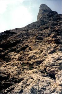
Approach: If staying in Val Gardena there are two options, either a short bus trip to the top of the Grodner Joch (Passo Gardena), or, as we did, take the Dante cepies gondola from the village of Wolkenstein, then the chair lift for a descent to the Grodner Joch. Having arrived there, take the well waymarked path No.666 which traverses below the imposing cliffs of the massif, crosses some scree below the Val Setus before leaving the trees and arriving at the Pisciadu waterfall. The alternative start for this route, starting from about 2.5 kilometres down the road from the Grodner Joch, joins here from below, and the start is marked by a cast iron plate giving the official name of the route @Via Ferrata Brigata Tridentina-Versicherter Pisciadu-Klettersteig' This is the place to gear up, putting on climbing harnesses, helmets, gloves and the Via Ferrata set, before clipping into the cable and starting up the steep rock cliff, aided by massive iron brackets set into the rock. This part of the route is often wet but the protection offered by the brackets and the cable is excellent. The route makes it's way towards the waterfall, but offers some interesting gymnastics and sometimes some welcome spray as it gets very close to the falls, with the fixed cable ensuring no route finding difficulties and protecting us in all the exposed sections. The steepness of the path eases as it enters a natural rock basin, with the Exner Tower looming above us on the right, and this marks the end of the first, original section of the route, and if desired an escape can be made to the left here, following the stream up towards the Pisciadu Hut on the natural rock terrace that extends all the way around the Sella massif.
Our way though leads right up the seemingly impossibly steep Exner Tower, starting with an exposed traverse across slabby terrain (good photo spot with views of the valley some 600 metres below in the background). The route then ascends a steep 'chimney' before turning right and, on going around the corner you find an almost vertical iron ladder leadingly dizzily skyward (remember my earlier remarks about absolute freedom from vertigo!) The route continues upwards, still steeply, until the gradient eases, and, around a corner to the left you meet the final hurdle, a narrow suspension bridge spanning the chasm between the main Sella massif and the free standing Exner Tower you have just climbed (another 'must' for a photo shoot!). Beyond the bridge the path No.666 continues, with frequent red waymarks to gain the natural rock terrace and the welcoming Pisciadu Hut and Lake Pisciadu, jade green and surrounded by the rock spires of the Sella, and Pisciadu summit which, if time allows, can be easily scaled in about 1.5 hours from the hut. The Pisciadu Hut offers simple meals and a wide range of refreshments and tourist items, including the Pisciadu Climbing Path T shirt, unavailable elsewhere! An excellent spot to recover from the climb, reminisce about the various obstacles overcome, and consider the way back down.
Leaving the Pisciadu we head almost due East on Path No.676 which traverses a more or less level plateau before zig zagging steeply down into the Val de Mezdi or Mittagstal. The steep descent is protected by a cable in places, but presents no difficulties and we are soon in the sandy valley, where we cross the river ( bridge), and turn left for an easy walk along Path No. 651 until, just before the path starts to drop more steeply down, we leave the path left down a steep gravelly slope on Path No.672, which leads easily immediately below the great cliff of the Masores Wall to rejoin our outward path near the spot where our climb of the Via Ferrata began at the cast iron plaque, and we return to the Grodner Joch easily along Path No. 666, our minds full of memories of an unforgettable day out that will stay with us for many years.
Suggested Maps
 - Carta Escursionistica-Wanderkarte - Val Gardena 1:25000
Stay Safe
Do enjoy yourself when out walking and choose a route that is within your capabilities especially with regard to navigation.
Do turn back if the weather deteriorates especially in winter or when visibility is poor.
Do wear the right clothing for the anticipated weather conditions. If the weather is likely to change for the worse make sure you have enough extra clothing in your pack.
Do tell someone where you are planning to walk especially in areas that see few other walkers.
Do take maps and other navigational aids. Do not rely on mobile devices in areas where reception is poor. Take spare batteries especially in cold weather.
Do check the weather forecast before leaving. The Met Office has a number of forecasts for walkers that identify specific weather risks.
Please Note - These walks have been published for use by site visitors on the understanding that Walking Britain is not held responsible for the safety or well being of those following the routes as described. It is worth reiterating the point that you should embark on a walk with the correct maps preferably at 1:25000 scale. This will enable any difficulties with route finding to be assessed and corrective action taken if necessary.