Italian Tribulaun Hut to Bremerhütte
Walk 6121
Country - Austria
Region - Brennerberge & Hochstubai
Author - Peter Hollington
Length - 6.6 km / 4.1 miles
Ascent - 742 metres / 2449 feet
Time - 5.00 hours
Grade - mod/hard
Click image to visit gallery of 7 images.
This is the final day of a three day route through changing mountain scenery from the Brenner pass area into the Stubai alps. It is a variant on the Jubilaumssteig.
From the Tribulaun the route takes you easily up good zig-zags to Pfferscher Scharte (Sandesjochl) (2599m, 231m ascent, 0.6km) from where there are incredible views.
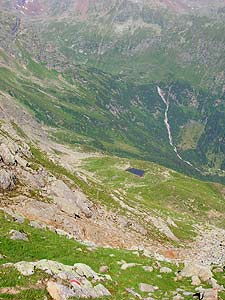
You now rejoin the Jubilaums steig. This is well-marked throughout but seemingly little walked. There are lots of up and down here with the ground often difficult where long grass covered holes. The descent into the Simmingbach cirque is steep but well-protected by wires and a ladder. Where the path crosses the Simmingbach river there is no bridge. If the river is high a leap from a high rock is the best way to cross.
Continue to the foot of Mitteregg (c2100m, 200m ascent, 5km). From here follow path 102 to the Bremerhütte (2411m, 311m ascent, 1km).
From here we followed the Hochstubaiweg to the west. Alternatively you can follow the Jubilaums steig to the east.
Note - altitude, ascent and distance (where appropriate) are given for each section of the route.
Suggested Maps
 - Alpenvereinskarte Number 31/3 "Brennerberge"- published by OAV
Stay Safe
Do enjoy yourself when out walking and choose a route that is within your capabilities especially with regard to navigation.
Do turn back if the weather deteriorates especially in winter or when visibility is poor.
Do wear the right clothing for the anticipated weather conditions. If the weather is likely to change for the worse make sure you have enough extra clothing in your pack.
Do tell someone where you are planning to walk especially in areas that see few other walkers.
Do take maps and other navigational aids. Do not rely on mobile devices in areas where reception is poor. Take spare batteries especially in cold weather.
Do check the weather forecast before leaving. The Met Office has a number of forecasts for walkers that identify specific weather risks.
Please Note - These walks have been published for use by site visitors on the understanding that Walking Britain is not held responsible for the safety or well being of those following the routes as described. It is worth reiterating the point that you should embark on a walk with the correct maps preferably at 1:25000 scale. This will enable any difficulties with route finding to be assessed and corrective action taken if necessary.