Three villages in the Alpujarras from Pampaneira
Walk 6128
Country - Spain
Region - Granada Province (Andalucia)
Author - Peter Bailey
Length - 6.0 km / 3.8 miles
Ascent - 500 metres / 1650 feet
Descent - 500 metres / 1650 feet
Time - 3.00 hours
Grade - easy/mod
Click image to visit gallery of 5 images.
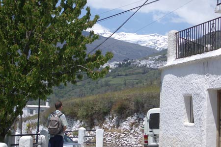
The Alpujarras was the last stronghold of the Moors. High up on the Mediterranean side of the Sierra Nevada, south of Granada, these villages were sufficiently remote to offer a safe home for the Moors some time after the Catholic Kings had re-conquered the rest of Spain. The Moorish influence is obvious in the architecture of the villages. Because the villages are so high in the mountains this walk would be suitable for a nice day even in late May, when there will still be snow on the higher mountains. Mulhacén, the highest mountain in mainland Spain can be seen from this walk.
Start the walk in Pampaneira from the Plaza de la Iglesia (Church Square). Walk up calle Estación to the higher part of the village, passing the old village wash house (lavadero). From the highest houses in the village there starts a path which leads to the next village, Bubión. You may spot blue waymarking on the way. Following this path you will soon find yourself passing above the flat roofs of Pampaneira with their characteristic chimneys and walking through the terraced landscape of the Poqueira valley. The Moors produced silk here in the past and you may well see the mulberry trees on which the silk worms fed. You will also see evidence of the "acequias", a complex system of narrow channels, designed to carry water from the mountain streams above to the terraces. You cross a small stream and then see an "era" or threshing area. Wherever the path divides you take the higher path and soon you will see Bubión with its church high above on the mountainside.
Continue until you pass the wash house in Bubión and arrive at the church square approximately 45 minutes after your departure from Pampaneira. There is at least one bar in Bubión but you could also have a drink from the fountain in the square by the church. Walking on, you pass the "polideportivo" or sports centre of Bubión which is signed. This will lead you onwards to the path up to Capileira. The path is generally parallel to the small main road and below it. In the fields on either side you may see cherries, chestnuts, walnuts etc.
There is a lovely square in Capileira with a bar, of course. From here you have 3 options. You can go back the same way you came or you can get a bus or taxi back. You could also take the path down from the lowest houses in the village to the river at Punte (bridge) Chiscar. Cross the bridge and return to Pampaneira along a pleasant path on the opposite side of the valley. You re-cross to the other side of the valley after you pass through a small wood of Spanish oaks just before Puente (bridge) de la Higuerilla also called Puente del Molino, because of the ruins of a mill next to the bridge. From here head for Bubión: you enter the village near to the sports centre and from there continue down your original path back to Pampaneira.
Stay Safe
Do enjoy yourself when out walking and choose a route that is within your capabilities especially with regard to navigation.
Do turn back if the weather deteriorates especially in winter or when visibility is poor.
Do wear the right clothing for the anticipated weather conditions. If the weather is likely to change for the worse make sure you have enough extra clothing in your pack.
Do tell someone where you are planning to walk especially in areas that see few other walkers.
Do take maps and other navigational aids. Do not rely on mobile devices in areas where reception is poor. Take spare batteries especially in cold weather.
Do check the weather forecast before leaving. The Met Office has a number of forecasts for walkers that identify specific weather risks.
Please Note - These walks have been published for use by site visitors on the understanding that Walking Britain is not held responsible for the safety or well being of those following the routes as described. It is worth reiterating the point that you should embark on a walk with the correct maps preferably at 1:25000 scale. This will enable any difficulties with route finding to be assessed and corrective action taken if necessary.