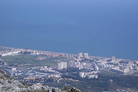
Monte Palomas from Alhaurin de la Torre near Torremolinos
Walk 6129
Country - Spain
Region - Malaga Province (Andalucia)
Author - Peter Bailey
Length - 7.0 km / 4.4 miles
Ascent - 400 metres / 1320 feet
Time - 3.00 hours
Grade - easy/mod
Click image to visit gallery image.
Monte Palomas is the big mountain behind Torremolinos. From the Torremolinos side it looks rather bare, hardly surpising since it is blasted by the sun and sea air all day long. The other side of the mountain is totally different: here you will find an idyllic mountain scene: in spring the variety of flowers is amazing. From the top you are rewarded with an excellent view of the bay of Malaga and on a clear day in "winter" (there is no winter as we know it) you can see many mountains in the province of Granada. There are also good views of Torremolinos and Benalmadena. You are very unlikely to get lost on this walk.
How to get there by car or taxi : Take the A-366 road (also called C344) from Malaga and pass the big roundabout near Churriana and then continue straight ahead towards Alhaurin de la Torre. Pass various new housing areas: a little before you reach the centre of Alhaurin de la Torre, when the restaurant Venta del Aleman is seen on your right, turn to the left taking a road in the middle of which are palm trees until (just after the bar Casa Paca) you take another road which forks off to your right at a roundabout. This road follows the line of the electric cables between cypresses, orange trees, and avocados. After following this road for 1 km you arrive at a small bridge over the arroyo (stream) Zambrano. We are at 185m altitude next to a fig tree with lots of branches. There is always space for parking here.
You can also get a bus to Alhaurin de la Torre (the Malaga to Coin bus) but do bear in mind that the walk does not start in the centre of the village. Getting the bus would add another 2 miles or so to the walk.
The Walk The path starts between the wall of a house on the left and an olive grove and the stream on the right. The stream is notable for its lack of water: it is nevertheless an attractive place. After about 300 yards you arrive at a wood of pine trees. Passing through this wood the path follows the left bank of the stream (right bank as you ascend): you are now 1km from the start of the walk. Then we change to the other side of the stream between pine trees, white rock rose, gorse, rosemary, spurge flax, sarsaparilla, etc. At 1.5 km we pass a stone wall, formerly a sheepfold opposite a small stream and we cross again to the left bank of the arroyo Zambrano.
We continue among palm hearts, kermes oak, wild asparagus and wild olive trees. Eventually we pass a "stream" joining the main stream from the left with marble "steps" which form a waterfall on the rare occasions when it rains. The path does a zigzag, beneath a rocky crag from which we have a good view of the Guadalhorce valley. At 500m height and 3 km from our point of departure we arrive at the Puerto del Canuto, a mountain pass amidst a thicket of rosemary etc. From here three paths lead off: the right one to the north goes to the cable car station above Benalmadena eventually, the path going downhill to the south terminates in Torremolinos. The path which goes up to the south east, on our left, goes to the summit of Monte Palomas. First it winds steeply then levelling out to the trig point at 598m and 3.5 km from the start. You return the same way that you came.
Stay Safe
Do enjoy yourself when out walking and choose a route that is within your capabilities especially with regard to navigation.
Do turn back if the weather deteriorates especially in winter or when visibility is poor.
Do wear the right clothing for the anticipated weather conditions. If the weather is likely to change for the worse make sure you have enough extra clothing in your pack.
Do tell someone where you are planning to walk especially in areas that see few other walkers.
Do take maps and other navigational aids. Do not rely on mobile devices in areas where reception is poor. Take spare batteries especially in cold weather.
Do check the weather forecast before leaving. The Met Office has a number of forecasts for walkers that identify specific weather risks.
Please Note - These walks have been published for use by site visitors on the understanding that Walking Britain is not held responsible for the safety or well being of those following the routes as described. It is worth reiterating the point that you should embark on a walk with the correct maps preferably at 1:25000 scale. This will enable any difficulties with route finding to be assessed and corrective action taken if necessary.