Pettenasco - Pratolungo - Monte Barro - Agrano Circular
Walk 6138
Country - Italy
Region - Lake Orta - Northern Italy
Author - Peter Bailey
Ascent - 340 metres / 1122 feet
Descent - 340 metres / 1122 feet
Time - 4.00 hours
Grade - easy/mod
Click image to visit gallery of 2 images.
To reach the start either drive from Orta to Pettenasco. Parking is available (see paragraph 2). You can also go by train or boat but do check the times of departure beforehand. Generally the going is easy but the climb to Monte Barro is fairly steep and long, so start the walk early in the day in especially summer. There is shade during much of the walk. Refreshments are available in Pettenasco and Agrano.
To reach the parking area turn right into via Vittorio Veneto opposite the church in Pettenasco. Turn right again into via per Armeno. You drive under the high railway bridge and over a bridge over the river Pescone. Park by the picnic area ahead. Walk back to the beginning of via per Armeno and take the steep footpath on the right immediately before the road junction, the via Prea Grossa. This walled cobbled path goes steeply up to Pratolungo.
Keep to the main path till you reach the first houses of the village. The road levels out in the village. Here keep walking up on the tarmac road through the village and make for the pretty little church straight ahead. At the junction by the church take the 2nd left past the children's playground. Walk on and take another left turn (via Pratolungo and signs for Crabbia) and then a turning on the right, via Regione Barro.
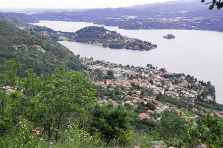
When this road ends a footpath continues in the same direction. Follow this, avoiding the left turn by a concrete wall with chain-link fence on top. When you come to the ruin of a small agricultural building on your right at a junction of footpaths going into the woods, take the second path on the left which very soon passes a bench on the right. After walking for about twenty minutes along this wide path you come to a signpost pointing to Pratolungo, Agrano and Monte Barro (also known as Monte Crabbia). Take the path for Monte Barro which will lead you to the cross (croce) on a rocky outcrop. Here you can enjoy a splendid view of the lake and Pettenasco below and the small town of Armeno to the east. Pella can be seen on the western banks of Lake Orta. Opposite the peninsula of Orta San Giulio and just south of Pella, the Sanctuary of the Madonna del Sasso stands on its rocky promontory above the lake.
When you have enjoyed the views and taken photographs for posterity, return along the same route to the signpost. From here follow the path to Agrano.This leads downhill through the woods with some impressive mountain views and down past the cemetery and church and into Agrano. There is a bar in Agrano which sells very inexpensive drinks.
When you leave the bar follow the main road towards Armeno for about 200 yards to another church at which you turn right into the road to Pratolungo. After a very short distance you will see a lane on your left with a red sign at the corner on a telegraph pole. Take this lane and follow this all the way to Pratolungo through fields and often alongside a stream or river. All the time you are walking parallel to Monte Barro on your right. At first you will be walking gently downhill and later as you approach Pratolungo the path ascends towards the village.
When the path ahead forks, take the right fork but later on follow the sign for Pratolungo to the left. You cross a small stream and later a little bridge over the river and soon arrive at the old village of Pratolungo, where you turn left into the Via Principale. Continue along this road as it winds through the village and at a junction you will see a road on the left with a children's playground and church at the end. This is the road you came up earlier in the walk. Follow this back to Pettenasco.
This walk could also be started in Orta, in which case you would follow the walk "Orta to Pettenasco via Carcegna" as far as the railway bridge in Pettenasco. This longer walk would last at least eight hours.
Stay Safe
Do enjoy yourself when out walking and choose a route that is within your capabilities especially with regard to navigation.
Do turn back if the weather deteriorates especially in winter or when visibility is poor.
Do wear the right clothing for the anticipated weather conditions. If the weather is likely to change for the worse make sure you have enough extra clothing in your pack.
Do tell someone where you are planning to walk especially in areas that see few other walkers.
Do take maps and other navigational aids. Do not rely on mobile devices in areas where reception is poor. Take spare batteries especially in cold weather.
Do check the weather forecast before leaving. The Met Office has a number of forecasts for walkers that identify specific weather risks.
Please Note - These walks have been published for use by site visitors on the understanding that Walking Britain is not held responsible for the safety or well being of those following the routes as described. It is worth reiterating the point that you should embark on a walk with the correct maps preferably at 1:25000 scale. This will enable any difficulties with route finding to be assessed and corrective action taken if necessary.