A short circular walk from Plaine Dranse
Walk 6139
Country - France
Region - Haute Savoie (74) - Morzines, Samoëns & Abondance
Author - Donald Morton
Ascent - 450 metres / 1485 feet
Descent - 450 metres / 1485 feet
Time - 4.00 hours
Grade - easy/mod
Click image to visit gallery of 6 images.
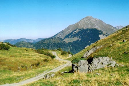
This walk is in the centre of the French/Swiss Alps area known as Les Portes du Soleil which straddles the border. It can be managed in half a day. (Par for the course from the direction signs is some 31/2 - 4hrs). It provides good views of the surrounding mountains but is itself only about 450 metres ascent.
It starts from the Chalets de Plaine Dranse which are reached by turning off the D22 onto the D228 at Chatel. There is parking in front of the tiny chapel at Plaine Dranse and the walk starts by taking the broad path to the left of the chapel. Follow the widest most obvious track as it climbs up behind the chapel (with views of Mont Le Grange across the valley) and swings sharply left to reach a signed junction. The right hand track can be taken to reach Tete des Lindarets or Pointe de Chesery, but our route takes the left hand path signed to Plan de Chesery, Cornebois and Chalets du Blattin. Again follow the most obvious track up, ignoring side tracks and crossing one or two pistes. All the way up there are views east and south of superb mountain panoramas. Eventually the track reaches the telesiege Chaux des Rosees terminal, and then climbs further to the highest point of the walk at the terminal of the telesiege de Cornebois. Here there are again good views of Mont Le Grange.
Two of my maps show that there is a path descending from here, mainly to the right of the chairlift. There is no signage and a third map, the Carte de Randonnee 3528ET, shows the path to be "of uncertain continuity" and unclear. And so, after a promising start, it turns out to be: very unclear across rough pasture. Better, certainly easier, to return down the track towards the Chaux des Rosees terminal. Just before reaching the terminal turn right downhill on a clear track slanting right, away from the Chaux des Rosees chairlift and towards the Cornebois chairlift. This track as it descends passes under the latter chairlift twice and reaches a track junction at Blattin. Turn right and go under the cables again to reach the summer hamlet of Chalets du Blattin, occupied by farm families only when the cows are on their summer pasture. Pass through and cross over the Rouisseau du Blattin and descend alongside it. Ignore one track to the left which leads to a terminal of a lift coming up from Pre le Joux. Then at the next two T-junctions turn left and follow the track out to the road. Turn left to reach the car park by the chapel in 100 yards or so.
Suggested Maps
 - IGN Carte de Randonnée - Morzine/Massif-du-Chablis/Les Portes du Soleil - 1:25000 Sheet 3528ET
Stay Safe
Do enjoy yourself when out walking and choose a route that is within your capabilities especially with regard to navigation.
Do turn back if the weather deteriorates especially in winter or when visibility is poor.
Do wear the right clothing for the anticipated weather conditions. If the weather is likely to change for the worse make sure you have enough extra clothing in your pack.
Do tell someone where you are planning to walk especially in areas that see few other walkers.
Do take maps and other navigational aids. Do not rely on mobile devices in areas where reception is poor. Take spare batteries especially in cold weather.
Do check the weather forecast before leaving. The Met Office has a number of forecasts for walkers that identify specific weather risks.
Please Note - These walks have been published for use by site visitors on the understanding that Walking Britain is not held responsible for the safety or well being of those following the routes as described. It is worth reiterating the point that you should embark on a walk with the correct maps preferably at 1:25000 scale. This will enable any difficulties with route finding to be assessed and corrective action taken if necessary.