Le Prarion from Bellevue, Les Houches
Walk 6020
Country - France
Region - Haute Savoie (74) - Chamonix Valley
Author - Lou Johnson
Length - 8.0 km / 5 miles
Ascent - 460 metres / 1518 feet
Descent - 460 metres / 1518 feet
Grade - easy/mod
Click image to visit gallery of 12 images.
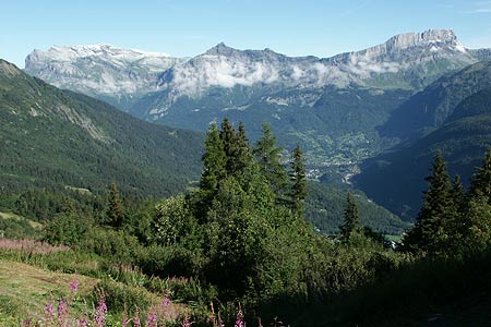
This high level promenade offers exceptional views over the Chamonix Valley, the north-west aspect of Mont Blanc and the impregnable limestone cliffs Rochers des Fiz and the Desert de Platé. It is possible to walk from Les Houches to Bellevue but it is far easier to use the cablecar to gain these 770 metres of ascent.
Shortly after exiting the cablecar upper station you are immediately presented with a fine mountain landscape as the name suggests. All the features mentioned above are in view and in addition you can see the summit of le Prarion (1967m) to the north-west. Turn right and follow the Tramway du Mont Blanc to Col du Voza. Here you continue climbing on the clear track to the Hotel du Prarion. From here a signed footpath leads on to the summit of Le Prarion. The ascent involves limited simple scrambling as you approach the summit. The view is better than the initial panorama enjoyed at Bellevue. If the weather is good then an afternoon walk would be preferable as the sun will light the whole of the western face of Mont Blanc whereas in the morning this side of the mountain is in shade.
After enjoying the view, retrace your steps back to Bellevue, perhaps stopping for refreshment at the small café at Col du Voza before tackling the last section of uphill walking back to the cablecar station.
For those of you tempted to make the journey to Nid d'Aigle (the upper station of the Tramway du Mont Blanc), please remember that reservations, although not obligatory, are essential as trains tend to ascend completely full.
Suggested Maps
 - Carte de Randonnées "Sheet A1 - Pays due Mont-Blanc" published by Rando Editions. 1:50000 scale - Sheet A1
- Map of Mountain Footpaths in Summer - 1:40000 - Published by the Office de Tourisme
- IGN Carte de Randonnée - Saint-Gervais-les-Bains - Massif du Mont Blanc - 1:25000 Sheet 3531ET
Stay Safe
Do enjoy yourself when out walking and choose a route that is within your capabilities especially with regard to navigation.
Do turn back if the weather deteriorates especially in winter or when visibility is poor.
Do wear the right clothing for the anticipated weather conditions. If the weather is likely to change for the worse make sure you have enough extra clothing in your pack.
Do tell someone where you are planning to walk especially in areas that see few other walkers.
Do take maps and other navigational aids. Do not rely on mobile devices in areas where reception is poor. Take spare batteries especially in cold weather.
Do check the weather forecast before leaving. The Met Office has a number of forecasts for walkers that identify specific weather risks.
Please Note - These walks have been published for use by site visitors on the understanding that Walking Britain is not held responsible for the safety or well being of those following the routes as described. It is worth reiterating the point that you should embark on a walk with the correct maps preferably at 1:25000 scale. This will enable any difficulties with route finding to be assessed and corrective action taken if necessary.