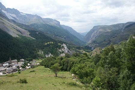
Villar d'Arène from La Grave - Ecrins
Walk 6042
Country - France
Region - Haute Alpes (05) - La Grave & La Meije - Ecrins NP
Author - Lou Johnson
Length - 6.5 km / 4.1 miles
Ascent - 350 metres / 1155 feet
Descent - 350 metres / 1155 feet
Time - 3.00 hours
Grade - easy/mod
Click image to visit gallery image.
This short walk provides an interesting circular route from La Grave enabling you to explore the attractive village of Villar d'Arène. The walk also offers an intimate view of the River Romanche.
Start & End - The village of la Grave on the N91.
At the eastern end of La Grave walk down the slip road that leads to Camping de la Meije and where it bends right continue across the River Romanche. Reaching the other side, turn left. Follow the footpath into the trees and bear left at the first junction. This path follows the river, which is on your left. The path climbs steadily with the river in a gorge below on your left.
Reaching a bridge across the gorge, cross to the north bank and continue along the path, which follows a ledge cut into the rocks. From this section you can see the river tumbling down the gorge. Quite soon after the ledge section you reach a road. Turn right here across a field to shortcut the road. On reaching the road again, keep straight ahead along a track where the road bends left. This leads past the cemetery and the church into the village square at Villar d'Arène. The village has a number of options for refreshments.
From the village square take the signed path by the side of the Auberge Aux Trois Frênes down to the bridge across the River Romanche. Cross the bridge and go right following the river downstream. You are now on GR54. The route ahead is easy to follow and after a short ascent you drop down to the river bridge by the Camping de la Meije. Walk up the access road into La Grave.
Suggested Maps
 - IGN Carte de Randonnée - Meije Pelvoux - Parc National des Ecrins - 1:25000 Sheet 3436ET
- IGN Carte de Randonnée - Valloire - Aiguilles d'Arves, Col du Galibier - 1:25000 Sheet 3435ET
Stay Safe
Do enjoy yourself when out walking and choose a route that is within your capabilities especially with regard to navigation.
Do turn back if the weather deteriorates especially in winter or when visibility is poor.
Do wear the right clothing for the anticipated weather conditions. If the weather is likely to change for the worse make sure you have enough extra clothing in your pack.
Do tell someone where you are planning to walk especially in areas that see few other walkers.
Do take maps and other navigational aids. Do not rely on mobile devices in areas where reception is poor. Take spare batteries especially in cold weather.
Do check the weather forecast before leaving. The Met Office has a number of forecasts for walkers that identify specific weather risks.
Please Note - These walks have been published for use by site visitors on the understanding that Walking Britain is not held responsible for the safety or well being of those following the routes as described. It is worth reiterating the point that you should embark on a walk with the correct maps preferably at 1:25000 scale. This will enable any difficulties with route finding to be assessed and corrective action taken if necessary.