Tribulaunhütte to Italian Tribulaun Hut
Walk 6120
Country - Austria
Region - Brennerberge & Hochstubai
Author - Peter Hollington
Length - 5.4 km / 3.3 miles
Ascent - 535 metres / 1766 feet
Time - 2.00 hours
Grade - mod/hard
Click image to visit gallery of 3 images.
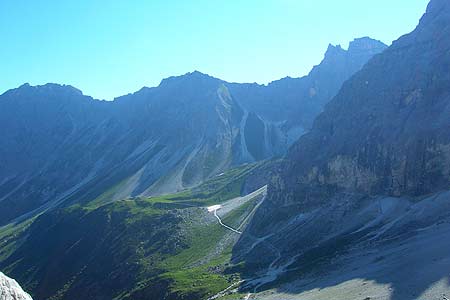
This is day two of a three day route through changing mountain scenery from the Brenner pass area into the Stubai alps. It is a variant on the Jubilaumssteig.
From the Tribulaunhütte take the path across scee to Pfferscher Scharte (2599m, 535m ascent, 2.75km). A landslip covered start here and path 59 and path 61 are a suitable alternative. Continue by descending on a good path to the Tribulaun Hut by a delightful lake (2368m, 0.6km). The Tribulaun hut is below impressively steep cliffs.
The next section continues to the Bremerhütte - More Details
Note - altitude, ascent and distance (where appropriate) are given for each section of the route.
Suggested Maps
 - Alpenvereinskarte Number 31/3 "Brennerberge"- published by OAV
Stay Safe
Do enjoy yourself when out walking and choose a route that is within your capabilities especially with regard to navigation.
Do turn back if the weather deteriorates especially in winter or when visibility is poor.
Do wear the right clothing for the anticipated weather conditions. If the weather is likely to change for the worse make sure you have enough extra clothing in your pack.
Do tell someone where you are planning to walk especially in areas that see few other walkers.
Do take maps and other navigational aids. Do not rely on mobile devices in areas where reception is poor. Take spare batteries especially in cold weather.
Do check the weather forecast before leaving. The Met Office has a number of forecasts for walkers that identify specific weather risks.
Please Note - These walks have been published for use by site visitors on the understanding that Walking Britain is not held responsible for the safety or well being of those following the routes as described. It is worth reiterating the point that you should embark on a walk with the correct maps preferably at 1:25000 scale. This will enable any difficulties with route finding to be assessed and corrective action taken if necessary.